Research Summary
My research focuses on the increasingly complex challenges for infrastructure in the Anthropocene. I hope to provide insights into how we can transition the management and design of infrastructure in the face of increasing complexity characterized by accelerating and increasingly uncertain conditions such as emerging and disruptive technologies (including artificial intelligence), climate change, financing, and cybersecurity/warfare. This work has led to recommendations for transitioning how we govern, educate for, and build infrastructure for the future. I am actively writing articles that explore these challenges with the hope of building a community of infrastructure researchers prepared to address these challenges.
A major thrust of my and my lab's research focuses on infrastructure resilience to climate change and extreme events. We view climate change as one of many challenges that infrastructure will need to be adapted to, one that needs significant attention given that it will most likely require new approaches for how we design and manage critical systems in the face of growing uncertainty. We deploy a multitude of approaches to address these challenges including reliability models to test how infrastructure will fail as hazards change, the simulation of interdependencies and cascading failure behavior across critically interconnected systems, and the exploration of alternative design approaches (such as safe-to-fail and decision making under deep uncertainty).
I continue to maintain contributions to the fields of infrastructure life cycle assessment and urban systems analysis. These fields of study have provided me with a systems perspective when it comes to infrastructure and urban activities, and their frameworks I find to be foundational in how I think about complex systems.
Interests
- Infrastructure & the Anthropocene
- Complexity of Infrastructure Systems
- Infrastructure Resilience & Sustainability
- Climate Change & Extreme Events
- Interdependencies & Cascading Effects
- Infrastructure as Wicked & Complex Processes
- Social-Ecological-Technological Systems
Products
Data products including metadata and dictionaries stored on ASU's Dataverse.
Technical documentation and selected course project reports stored on ASU's electronic repository.
Interactive spatial data library hosted on ArcGIS.
Selected Research Projects
-
 The SW-IFL will advance urban systems science by: (1) improving our understanding of how the built environment affects local to regional climates, emissions, and air chemistry; (2) establishing empirically-grounded theory of how governance, actors, plans, and policies across scales shape resilience to heat; (3) building a framework and simulation capability to facilitate equitable mitigation of extreme heat and its societal impacts via analysis of co-benefits and tradeoffs of sustainability outcomes; and (4) engaging stakeholders who represent many scales of government and the community in an advising and co-discovery role to drive the research process toward decision-relevant knowledge.
 -
 We will develop a novel integrated modeling framework that simulates the response of interdependent ISs to a range of current and future climate events for different design scenarios. We will adopt models of the physical systems to simulate IS performance in a spatially distributed fashion over long-term periods, using climate model data downscaled to commensurate spatiotemporal scales. We will then integrate the infrastructure models through a failure propagation scheme that allows quantifying the risk of failures in single ISs and cascading failures caused by interdependencies. After building confidence in the integrated model, we will perform long-term simulations of infrastructure performance under historical and future climate scenarios to assess the resilience of ISs (i) in their current fail-safe configuration and (ii) under a set of design scenarios where the most critical components of the current configuration are replaced with safe-to-fail solutions.
 -
 As the realities of aging infrastructure come head to head with climate hazards, the capabilities to assess vulnerabilities and proactively respond have become necessary. Energy systems appear particularly vulnerable, as aging buildings must function in gradual and extreme environments that are changing, and the grids they rely on are directly exposed to new hazards. And climate uncertainty necessitates new approaches that embrace dynamic planning. We propose to develop and integrate a suite of cutting-edge models to advance planning capabilities for DOD facilities around building energy systems in the face of climate change. This will involve creating building energy simulations that consider technology and climate change, synthetic power distribution models to estimate grid operations, and combined vulnerability assessments that describe how buildings are vulnerable to future climate shocks.
 -
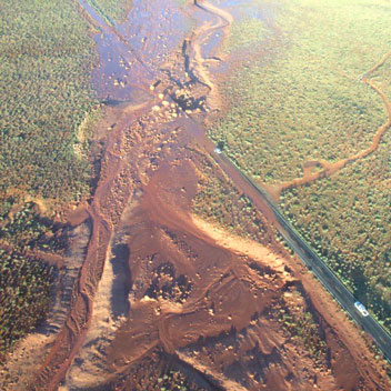
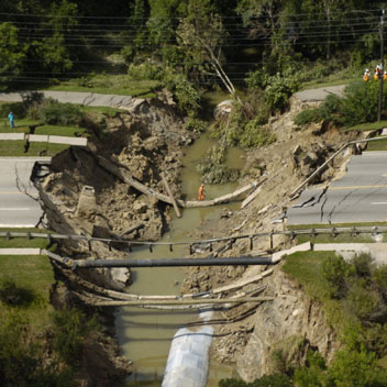
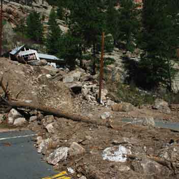 Case studies have focused on California and Arizona. The research has produced a first-of-its-kind probabilistic assessment of roadway and power infrastructure fire and post-fire debris flow risk, considering the changing risk of fires and precipitation, and the characteristics of watersheds and regions, and the criticality (importance) of infrastructure assets.
 -
The objective of this Growing Convergence Research project is to explore how social, ecological, and technological systems (SETS) interact to generate vulnerability or resilience to extreme weather events and how urban SETS dynamics might be guided along more resilient and sustainable trajectories. This project is motivated by the challenge of minimizing the impacts of extreme events, such as hurricanes and the accompanying storm surges, extreme heat, and flash flooding brought on by heavy rain events, on cities. The research team will develop convergence a) by bridging across the social, ecological, and technological domains; b) integrating socio-ecological-systems (SES), socio-technological systems (STS), and engineering theories of resilience into a common definition of resilience in which adaptive capacity is central; and c) working together with practitioners and community members to collaboratively envision resilient urban futures and articulating needs for implementing system-oriented solutions.
Utilizing Atlanta, New York, Phoenix, and San Juan as study cities, this project will: a) apply and integrate simulations of power, water, transportation, and building systems to assess vulnerabilities to extreme events for future infrastructure scenarios in each city; b) model projections of heat and flood exposure combined with land use/land cover (LULC) change scenarios to assess future extreme event risk for future infrastructure scenarios in each city; c) analyze governance networks that address resiliency and associated actor agency, including visions, mental models of system vulnerabilities, institutional structures, and decision-making processes that are essential to navigate transformational changes in future scenarios; d) employ participatory visioning to co-develop future scenarios of resilient SETS infrastructures and explore with practitioners responses to future extreme event scenarios and social-ecological-technological changes; e) develop a researcher-practitioner transdisciplinary process to explore how resilience solutions might be implemented in diverse urban systems; and f) synthesize outcomes of future simulations and scenarios in an online interactive researcher-practitioner visualization platform as a potential decision-support tool.
-

The United States is highly urbanized with more than 80% of the population residing in cities. Cities draw from and impact natural resources and ecosystems while utilizing vast, expensive infrastructures to meet economic, social, and environmental needs. The National Science Foundation has invested in several strategic research efforts in the area of urban sustainability, all of which generate, collect, and manage large volumes of spatiotemporal data. Voluminous datasets are also made available in domains such as climate, ecology, health, and census. These data can spur exploration of new questions and hypotheses, particularly across traditionally disparate disciplines, and offer unprecedented opportunities for discovery and innovation. However, the data are encoded in diverse formats and managed using a multiplicity of data management frameworks -- all contributing to a break-down of the observational space that inhibits discovery. A scientist must reconcile not only the encoding and storage frameworks, but also negotiate authorizations to access the data. A consequence is that data are locked in institutional silos, each of which represents only a sliver of the observational space. This project, SUSTAIN (Software for Urban Sustainability to Tailor Analyses over Interconnected Networks), facilitates and accelerates discovery by significantly alleviating data-induced inefficiencies. This effort has deep, far-reaching impact. It transforms urban sustainability science by establishing a community of interdisciplinary researchers and catalyzing their collaborative capacity. Hundreds of researchers from over 150 universities are members of our collaborating organizations and will immediately benefit from SUSTAIN. Domains where spatiotemporal phenomena must be analyzed benefit from this innovative research; the partnership with ESRI and Google Earth amplify the impact of SUSTAIN, giving the project a global reach and enabling international collaborative initiatives. The direct engagement with middle school students in computer science and STEM disciplines has well-known benefits and, combined with graduate training, produces a diverse, globally competitive STEM workforce.
SUSTAIN targets transformational capabilities for feature space exploration, hypotheses formulation, and model creation and validation over voluminous, high-dimensional spatiotemporal data. These capabilities are deeply aligned with the urban sustainability community's needs, and they address challenges that preclude effective research. SUSTAIN accomplishes these interconnected goals by enabling holistic visibility of the observational space, interactive visualizations of multidimensional information spaces using overlays, fast evaluation of expressive queries tailored to the needs of the discovery process, generation of custom exploratory datasets, and interoperation with diverse analyses software frameworks - all leading to better science. SUSTAIN fosters deep explorations through its transformative visibility of the federated information space. The project reconciles the fragmentation and diversity of siloed data to provide seamless, unprecedented visibility of the information space. A novel aspect of the project's methodology is the innovative use of the Synopsis, a spatiotemporal sketching algorithm that decouples data and information. The methodology extracts and organizes information from the data and uses the information (or sketches of the data) as the basis for explorations. The project also incorporates a novel algorithm for imputations at the sketch level at myriad spatiotemporal scopes. The effort creates a collaborative community of multidisciplinary researchers to build an enduring software infrastructure for urban sustainability.
-

Flooding is the most damaging natural hazard in the U.S. and around the world, and most flood damage occurs in cities. Yet the ability to know when flooding is happening and communicate that risk to the public and first responders is limited. At the same time there is a surge in digitally connected technologies, many at the fingertips of the general public (e.g., smartphones). The need is for new flood information that can be generated from primary observations that are collected in exactly the right places and times to be coupled with the ability to more effectively communicate this risk to communities. This project will develop the Integrated Flood Stage Observation Network (IFSON), a system that can take in crowd-sourced information on flooding (from cameras, a smartphone app, and social media), intelligently assess flood risk (using machine learning), and communicate those risks in real time. IFSON will be scalable to any community or city and will provide a backbone for new crowd-sourced technologies.
This project will i) integrate several new technologies (each that directly engages with different communities) to provide new insights into and communication capacity around urban flooding hazards, ii) connect a range of communities to each other in near-realtime (from the general public to first responders to infrastructure managers) and develop flood sensing and avoidance capacities that can be used anywhere in the U.S. or even internationally, iii) develop new insights into how urban morphology contributes to flood risk, and iv) leverage prior funding by connecting practitioners from existing sustainability research networks and sending data to CUAHSI and eRams. Additionally, this research will develop outreach activities that will educate the public and practitioners on how flooding hazards occur, their impacts, and how to mitigate risks. The research will directly empower and engage local citizens in flood event reporting and response, and explores a concrete model for what it would mean to have a "smart and connected community" for minimizing flood risk. Although driven by a number of novel technologies and techniques, the central focus of this work is on the interface of community with technology and, in particular, how modern network technologies can engage and bring together ordinary citizens, city planners, first responders, and other local stakeholders within a shared, collaboratively constructed information space; a broad range of educational and outreach opportunities are included to engage stakeholders and amplify project impact. In addition to training students through research positions, the project will create a summer Research Experience for Undergraduates (REU) program.
It will also connect with national, state, and local societies across a number of disciplines. For example, the project will work with the City of Phoenix during their Monsoon Preparedness day to educate first responders on how to use project results. Interdisciplinary course modules that show how to engage various communities (including the public, first responders, and infrastructure managers) in mitigating flood risk will be developed and disseminated. Additionally, infrastructure managers will be recruited to participate in workshops on how project data will reveal new insights into the condition of infrastructure and what strategies can be employed to reduce hazards.
-

Trees are now ubiquitous components of urban landscapes in the United States. Increasingly urban trees are called upon as a form of living (i.e., green) infrastructure that is used to meet a variety of municipal goals to provide ecosystem services and combat the effects of climate change that, for many cities in the US and abroad, is causing an increase in the urban heat island effect. However, using trees as a form of infrastructure raises new challenges compared to traditional gray infrastructure typically managed by cities. This research addresses major knowledge gaps in our understanding of the effectiveness and capacity of urban trees to provide the services expected within the structure of municipal tree planting, stewardship and decision making and community interaction. Living infrastructure is a socio-environmental-technological system of feedbacks between organisms, the environment, societal desires, and governance capacity. In the case of urban trees, their capacity to meet municipal goals is uncertain and likely varies among cities. Part of this uncertainty exists because the ability to adequately model the effect of urban trees on their local environment suffers from a lack of quantitative information and scientific study. At the same time, the capacity of institutional managers to successfully steward urban trees is also unclear. Taken together, cities may have goals for tree-derived functions that are disconnected from both the biophysical realities of what trees can do and realities and limitations of community management practices. Broader impacts of the work include student and postdoc training in convergent research, providing data and findings to inform municipal decision making, and informing the public and other stakeholders of the role of living infrastructure in cities via social media and other outreach mechanisms.
This is a pilot project with an overarching goal to understand the intellectual and institutional factors that have driven the movement to use urban trees as living infrastructure to produce ecosystem services. Project activities will evaluate the capacity of municipal institutions to implement and manage urban trees as living urban infrastructure to achieve climate goals. The project addresses key uncertainties in the socio-environmental system that considers urban trees as living infrastructure. It will examine how existing municipal forestry goals and plans vary throughout the United States, and how municipalities currently frame the role of living infrastructure in climate mitigation and adaptation. It also examines how current scientific understanding aligns with these goals and what information is needed for monitoring, modeling, and validation of these processes. the project includes the evaluation of existing municipal urban forestry plans from 20 cities throughout the United States. Data will be evaluated from the different disciplinary perspectives: i.e., ecosystem science, community ecology, ecohydrology, cultural geography, engineering, and landscape architecture. These data will be complemented with additional data collection and stakeholder interviews at three focal research cities: Los Angeles, California; Phoenix, Arizona; and Baltimore, Maryland. Work packages include a whole-team 1- to 2-day synthesis meeting in each of the three focal cities where existing data will be examined and discussed by the group. This will be followed by a half day workshop that engages local stakeholders. Meetings will focus on addressing research questions and further elaborating the coupled socio-environmental theory of living infrastructure. A Technical Advisory Committee will be constituted and their input on stakeholder decision making will be incorporated into the work plan. This effort will substantially contribute to a more comprehensive theory of living infrastructure as an interface between social, environmental, and technological systems and as a key component of novel urban ecosystems that can vary dramatically at national scales. Societal benefits of the project include the direct dissemination of our research findings to urban land management and forestry professionals, and new interdisciplinary training opportunities for postdoctoral and undergraduate trainees. Project results will directly address the needs of municipalities and their tree planting programs, which often seek to expand urban cover and diversity at great expense, but with a paucity of available scientific information.
-
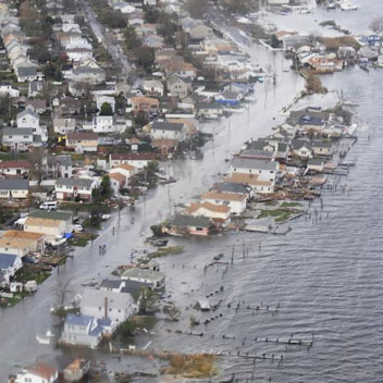
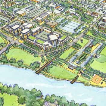
Urban areas are vulnerable to extreme weather related events given their location, high concentration of people, and increasingly complex and interdependent infrastructure. Impacts of Hurricane Katrina, Superstorm Sandy, and other disasters demonstrate not just failures in built infrastructure, they highlight the inadequacy of institutions, resources, and information systems to prepare for and respond to events of this magnitude. The highly interdisciplinary and geographically dispersed Urban Resilience to Extremes Sustainability Research Network (UREx SRN) team will develop a diverse suite of new methods and tools to assess how infrastructure can be more resilient, provide ecosystem services, improve social well being, and exploit new technologies in ways that benefit all segments of urban populations. Starting with nine network cities (six continental U.S. and three Latin American, home to over 35 million residents) and expanding in future years, the vision of the UREx SRN is to co-produce the knowledge needed to promote resilient, livable cities in a future that will look very different from today. The extreme events that this project will focus on include urban flooding, coastal storms, regional droughts, and extreme heat waves. These events are already occurring with shocking frequency in U.S. and global cities. Infrastructure is viewed as an important line of defense against hazards and disasters, yet current urban infrastructure is aging and proving inadequate for protecting city populations. The UREx team will link SRN scientists, students, local practitioners, planners, industry, NGOs, and other stakeholders across >25 institutions and >70 collaborators to co-produce data, models, images, stories, and on-the-ground projects that show how a new resilient infrastructure can be developed. Infrastructure that is flexible, adaptable, safe-to-fail, socially equitable, and ecologically based will enhance urban resilience in the face of a higher incidence of extreme events, more culturally diverse communities, and continued urbanization pressures. Ultimately, the UREx SRN will help accelerate knowledge generation and application to encourage innovative strategies towards urban sustainability.
The Urban Resilience to Extremes Sustainability Research Network (UREx SRN) will develop a novel theoretical framework for integrating social, ecological, and technological system (SETS) dimensions for conceptualizing, analyzing, and supporting urban infrastructure decisions in the face of climatic uncertainty in a more holistic way. The primary research question is: how do SETS domains interact to generate vulnerability or resilience to extreme weather related events, and how can urban SETS dynamics be guided along more resilient, equitable, and sustainable trajectories? The foundation of the network is eight working groups (WG) who will work together to answer this question. Network activities include: assembling comparable datasets for the cities; doing advanced climate and hydrological modeling and downscaling; conducting comparative analyses; further developing the SETS conceptual framework; experimenting with new visualization and computation approaches for representing the data and the SETS framework; using these products in participatory modeling and scenario analysis for each city; and developing the science and practice for transitioning infrastructure to meet 21st century resilience and sustainability goals. Continual network and educational evaluation will allow realignment and adjustment of the work based on iterative assessments. The program will develop a suite of interactive educational activities spanning institutions across the network, and including local practitioners as well as university students and young professionals. Working Groups include integral educational, communications, and diversity-enhancing activities for graduate and post-doctoral fellows, early-career researchers, and city professionals aimed at developing a model for co-producing effective and robust decision-support tools and educating the next generation of scientists and practitioners to carry out this work. These programs are expected to be especially attractive to Hispanic students and practitioners due to the project's focus on understanding the increasing cultural and intellectual connections of the U.S. and Latin America.
The strategic goals of the UREx SRN are to: 1) Build a network of cities, institutions, and student, post-doctoral, and faculty researchers to explore resilience of cities to extreme weather related events; 2) Develop novel theoretical frameworks that express a vision of sustainable, integrated urban infrastructure that is flexible, adaptable, safe-to-fail, socially equitable, and ecologically based; 3) Work with practitioners and decision makers, as well as a cadre of graduate and post-doctoral fellows, to co-produce knowledge that facilitates data-driven visioning and ultimately transitions to a sustainable future for urban infrastructure and, by extension, the fabric of urban social-ecological-technological sustainability; and, 4) Create a model for incorporating assessment, learning, and adjustment in response to evaluative feedback in a large, transdisciplinary, multi-institutional, multi-national research network.
-
Vulnerability can take on many forms including immediate loss of critical resources, shortage of resources, and direct human health impacts. Understanding how climate change creates short-term vulnerability (e.g., equipment failure in extreme heat events) and long-term vulnerability (e.g., water shortage and rising ambient temperatures) can aid the US Navy to plan, deploy, and manage bases in both tactical and relief efforts.
Our work integrates power and water infrastructure modeling into an interactive modeling simulator-based training suite known as the Resilient Infrastructure Simulation Environment (RISE). That work supports the identification, adaptive response, and mitigation of cascading failures that are the result from complex interactions between interdependent infrastructures operating in planning mode or in real-time simulation. The proposed work will incorporate climate change modeling and infrastructure characterization of military bases to permit the US Navy and other DoD branches to design and implement more resilient military bases and procedures.
This work will (1) reveal how infrastructures are interdependent in US Military bases, (2) describe how the vulnerabilities in US Military base infrastructure are exacerbated by climate change, (3) enumerate how these vulnerabilities increase the potential of failure within individual infrastructures as well as cascades to other infrastructures, and (4) evaluate human-environmental-infrastructure interactions to refine and support decision-making to avoid conflict and increase stability. Strategies to reduce fossil fuel dependence are an example outcome of this work that is directly pertinent to conflict avoidance. This particular example also provides second- and third-order benefits that address DoD’s aggressive energy goals through increased mission capability, improved autonomy (mission duration), saved lives from reduced fuel transport, and reduced expenditures. The modeling suite will facilitate the identification of other synergistic and multiplicative opportunities for stakeholders.
-

Exposure to heat is a growing public health concern in many cities across the globe. In the US, Southwest cities have experienced increasing numbers of heat waves in the past few decades, and global climate models project significant increases in both the duration and intensity of these extreme events. Facing these challenges, very little is known about how people are exposed to heat during their day-to-day activities as they interact with urban infrastructure. To understand exposure, factors including the types of homes people live in (and whether they have and use air conditioning), their mobility choices, the quality of the infrastructure (e.g., shading, landscaping, and material choice), their work situation (e.g., air conditioned office versus outdoor worker), and their activity profiles must be considered. A systematic framework that any city can use to understand how people are exposed to heat and proactively mitigate risk is needed.
To create insight into how people are exposed to heat, this work will develop an Urban Activity Heat Simulation (UAHS) platform that will join (1) a model of residential and workplace exposure, (2) travel simulations for automobile use, public transit, and biking/walking, (3) urban infrastructure characteristics, (4) high-resolution urban climate data, and (5) a model of exposure thresholds. UAHS will be developed using Phoenix, Arizona and Los Angeles, California as case studies. Heat performance models for buildings will be combined with surveys of home and work activities to assess how people experience heat indoors. Using national and regional travel surveys combined with detailed travel models, simulations of how people move throughout cities will be developed. Downscaled climate models will be used to estimate present and future outdoor conditions in both cities. Information on infrastructure including materials, landscaping, and shading will also be used to develop estimates of outdoor exposure. Combining simulated exposures with health records will provide new insight into dangerous heat exposure profiles. The platform will be validated with in situ monitoring. UAHS will be developed with the goal of enabling any city to build upon the platform for their unique population and infrastructure.
-
 We developed a simulation to estimate mobility impacts of transportation infrastructure outages due to climate change. Scenarios were developed using Arizona as a case study for bridge failures and roadway closings due to intense rainfall events and flooding.
 -
 This project will develop a sophisticated and in depth description of future demand, grid response, and vulnerability due to increased (and prolonged) heat events in Southern California Edison (SCE) territory under current and future climate scenarios. It will enable innovative grid management and operation strategies and will identify adaptation guidance. Ultimately, this research will prepare utilities, the State, and local governments to better prepare for the here-to-unknown (but inevitable) strain resulting from the demand in increased electricity consumption due to heat events caused by climate change. The project requires a multi-disciplinary team with unique skill sets, including those of climate scientists, energy experts, urban planners, geo-spatial experts, and civil engineers. The project will provide: » Downscaled global climate models of future extreme heat events in Los Angeles County; » A report on the expected electricity demand increases due to average temperature increases and extreme heat events under different climate scenarios; » A report of grid vulnerability, with suggestions for adaptation to guide future planning and investment; » GIS map visualizations of research findings and analysis, which will enhance local governments and SCE’s public outreach and stakeholder engagement. The maps and accompanying data will comply with PUC privacy guidelines and will be made available to the public; and, » Coordinated outreach and education public displays that protect privacy (and potentially more classified documents for the IOUs and the CEC).
 -
The project will construct a new computer-based Resilient Infrastructure Simulation Environment (RISE) to allow individuals, groups (including students), and experts to test infrastructure network design configurations and crisis response approaches in three socio-technical infrastructure systems: electric power, water, and roadway networks. Researchers will link social and technical analysis with human subject research to discover the adaptive actions, ideas, and decisions that contribute to resilience. The project comprises of two major parts. In Part I (Modeling), researchers will identify the structure, dynamics (functionalities), and vulnerabilities of the networks that make up water, roadway, and electric power systems in Phoenix, AZ and Indianapolis, IN. Researchers will analyze the resulting US-based network models in conjunction with those from international partners in Asia, Australia, and Europe to learn and adapt global resilience principles . The results will be combined with belief networks to develop realistic decision models for the RISE. In Part II (Simulation), researchers will construct the RISE to study how different experts, stakeholders, individuals, and groups act in simulated decision scenarios. Through observation, researchers will identify the problem-solving and response strategies that result in resilient action, and thus understandthe organizational and social processes of sensing, anticipating, adapting, and learning.
Taken together, this project will result in two principal research outcomes: 1) a measureable, testable description of resilience that fuses social, behavioral, and engineered elements for infrastructure system design, and 2) improved resilience among the students, managers, stakeholders and other participants participating in the study. The new knowledge will help policymakers design effective strategies to make America's water, power, and road networks more resilient.
-
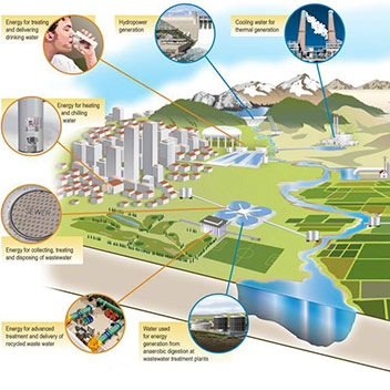
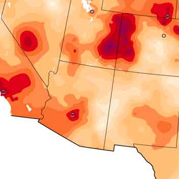
Western US regions are expected to experience more heat days, water shortages, intense precipitation events, forest fires, and increased peak power demands in the future. Desert regions are particularly vulnerable to future climate-induced environmental changes, given their scarce water resources and heavy reliance on thermoelectric power generation. As climate-related environmental events become more common, water and electricity managers will be either directly or indirectly exposed to vulnerabilities in the interdependent water-electricity systems. These vulnerabilities may arise because the infrastructures were designed for a climate and demand profile that may be significantly different than what will be experienced in the coming decades, and because the institutions that manage the systems do not yet have anticipatory governance structures that would enable them to proactively address the future. This project will develop a framework for assessing coupled water and electricity infrastructure-institution vulnerability at cross-scales to future climate events. It will create an educational game for infrastructure managers to learn how to anticipate future vulnerable states of the infrastructure and proactively deploy physical and institutional changes that will improve the resilience of the coupled systems.
While research has studied the interdependencies between water and electricity infrastructure, little is known about how the vulnerability in one system may propagate to the other, and especially about how the operational governance structures of these systems should be adapted for a climate-constrained future. There is a need to better understand how the governing of water and electricity services from the regional to the local level can be coordinated to proactively reduce future climate vulnerability. Using Arizona as a case study, this project will develop (1) a cross-scale (subsystem to the region) model of the water and electricity systems, (2) an institutional assessment that includes infrastructure managers, decision makers, and policies that control or impact each component of the water and electricity infrastructure, and (3) an extreme climate vulnerability assessment that joins physical infrastructure characteristics with the institutional processes that govern them. With this coupled infrastructure-institutional vulnerability assessment we will (4) develop a learning game for infrastructure managers to both teach them about the vulnerabilities in the coupled infrastructure and also help them understand how their institutional structures can be proactively changed to improve systemwide resilience. Through a series of workshops with infrastructure managers from the US Southwest, we will (5) test the game and also facilitate visioning and scenario analysis exercises. We will create new knowledge and methods for assessing water and electricity systems that acknowledges that failure can propagate through complex systems and can start with vulnerabilities in both physical and institutional infrastructure. We will then explore how novel game-based learning approaches can provide researchers and infrastructure managers with knowledge of the complex system and an understanding of the strategies that are needed to create anticipatory governance for a climate-constrained future.
During the project, we will convene infrastructure managers to not only test our game but to also participate in visioning and case study exercises, and using this knowledge create an educational platform for the public, technical workforce, and university students. The learning game will ultimately be deployed to a publicly available website and a series of sustainable infrastructure transitions guidance documents will be developed for municipal water and electricity, agricultural water, and power generation users and organizations. We will then create a platform for anticipatory governance of climate vulnerabilities by creating a forum program for the Arizona Science Center, build communication tools for community leaders and engineering/technical workforces, and a curriculum for university students. Ultimately, we view the research as an important first step for identifying how next generation sustainable infrastructure should be deployed and managed. As such, we anticipate that the findings will have broad appeal to academics and infrastructure managers not only in the US but also internationally.
-
 We developed a multi-criteria decision analysis framework and decision support spreadsheet to assistant transportation agencies in decision making for climate change. The framework and spreadsheet were developed using Interstate 10 in Arizona as a case study but are broadly applicable. Different infrastructure strategies to protect against heat and flooding were analyzed.
 -
Door-to-door trips often consist of multiple modes of travel and there has been little insight to-date of the greenhouse gas implications of driving to or from transit. We developed an environmental life cycle assessment of multi-modal trip travel in the Los Angeles metropolitan region to characterize emissions from door-to-door travel.
For final results, see:
Greenhouse Gas and Air Quality Effects of Auto First-Last Mile Use With Transit, Chris Hoehne and Mikhail Chester, Transportation Research Part D, 2017, 53, pp. 306-320, doi: 10.1016/j.trd.2017.04.030. -
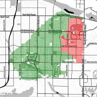
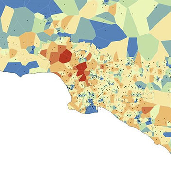
The vulnerability to heat of urban Southwest populations is a combination of social and built environment (infrastructure) factors. To date, heat vulnerability research has largely been focused on social factors (including age, chronic disease, poverty level, and English proficiency, among others) and few studies have considered how infrastructure enables or restricts access to cooling. New methods are needed for i) categorizing and quantifying the significance of infrastructure systems in providing protection from heat, and ii) joining social and infrastructure vulnerability to heat indices into a single framework that will allow city agencies to prioritize investments.
The Southwest is expected to experience more heat days and water shortages in the future which magnifies the need to characterize the vulnerability of population subgroups to heat events as a function of both socio-demographic and built environment characteristics. Social vulnerability analysis has provided valuable insight into the socio-demographic factors that put communities at risk during heat events, but little is known about how infrastructure systems amplify vulnerability. Building construction practices, home air conditioning, electricity generation and transmission, and cooling centers can contribute to a community’s heat-related vulnerability. This project will develop methods for joining social and built environment vulnerability into a single framework, and will create a prioritization framework for selecting investments in cooling infrastructure that maximize the reduction in vulnerability across two Southwest counties: Los Angeles and Maricopa (Phoenix metro area).
The proposed integrated social and infrastructure vulnerability framework will produce novel methods for estimating the additional risk to heat that result from built environment characteristics, and will identify efficient cooling infrastructure investment strategies for reducing this risk. The project will focus on two urban areas that are highly vulnerable to heat, with large socio-economic disparities, immigrant communities, linguistic isolation, and increasingly uncertain water supplies, as well as very different infrastructure (Los Angeles grew largely between 1940-1980 and Phoenix from 1980 on). (a) Environmental, social, and infrastructure vulnerability indices will be developed. The infrastructure indices will include building shell analysis, home air conditioning, electricity generation and transmission, and cooling centers, at a census tract resolution. (b) The indices will be joined to create a socio-technical vulnerability index (STVI). (c) The STVI will weigh the infrastructure vulnerability indexes against the social and each other to account for the relative impacts of infrastructure services on morbidity and mortality outcomes, using two approaches for weight estimation: regression and stochastic assessment. The use of two approaches will provide the research team with an opportunity to i) assess the feasibility of developing infrastructure index weightings from existing urban built environment and morbidity/mortality data and ii) develop novel stochastic weighting methods for cities when low quality data exist to assess the likelihood that one infrastructure characteristics is more or less significant than another. (d) The weighted STVI index will be used to develop a framework for assessing how cities should prioritize infrastructure investments by considering building weatherization, air conditioning rebates, rooftop solar, tree planting, and cooling center placement. (e) The STVI and prioritization strategies for Los Angeles and Maricopa will be compared to understand the socio-demographic and built environment differences between each county and identify the key drivers that other cities should focus on.